ESI faculty often participate in outreach events with local public schools or youth visits to campus. The following are free materials developed by ESI faculty for educators and students in physics, mathematics, engineering, and electronics. They may require purchase of materials from a hardware store or access to computers.
Summer 2026 registration is open now for the following courses! Click here to sign up and for more information on UMBC’s Summer Enrichment Academy programming.
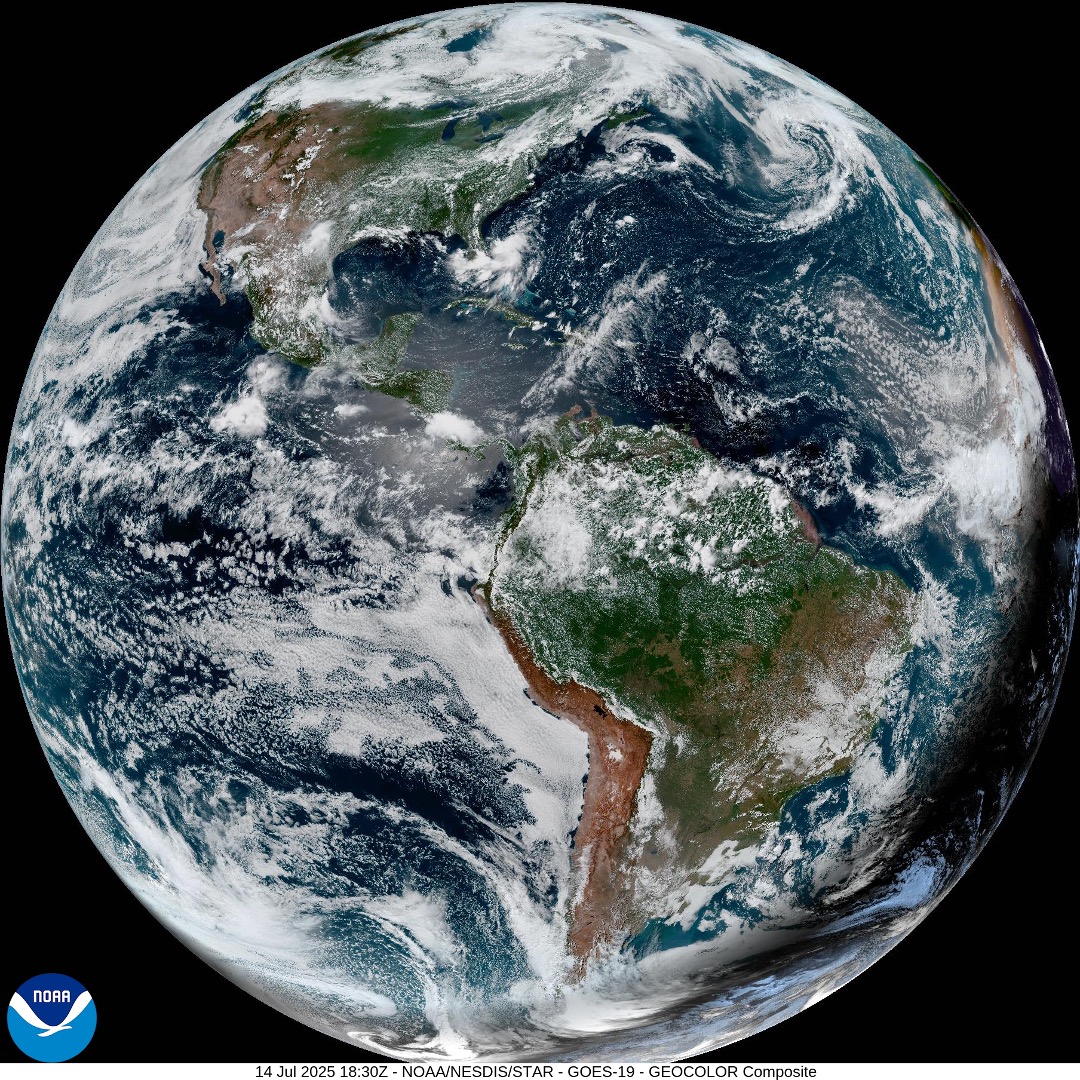
Summary: Satellite images of the Earth from space are some of our best tools to study our weather, oceans, pollution, and changes to our cities, rainforests, and polar caps over time. In this class, you will learn why scientists measure the entire Earth from space daily. We’ll also talk about the different kinds of signals we measure from space – specifically, how to identify liquid water from ice clouds, algae blooms from sediment in the ocean, desert dust from wildfire smoke – and all from satellite imagery. You’ll also get hands-on experience with satellite data from an exciting new NASA climate mission called PACE (which stands for Plankton, Aerosols, Clouds, ocean Ecosystem). PACE has a special camera on the spacecraft called HARP2, which was built right here at UMBC! This class will culminate in a laboratory tour of the Earth and Space Institute, research labs in the UMBC Physics building where we build and calibrate new satellite instruments, like HARP2 – and a discussion on how to join this rapidly-growing field.
Register now for summer 2026! Sign up for this class here.
Materials: Google Drive
Unit Length: up to 15 hours
Pre-Requisites: Students should have a general understanding of computers. Access to a smartphone is desired, but optional. Mathematics knowledge up to Algebra I is recommended.
Notes: The code and course was developed with Unix/Linux systems in mind, which include Apple Macs. Windows instructions are available as part of the Google Drive package.
Developed by Dr. Brent McBride/ESI for the Earth Science with Satellite Imagery course as part of the 2025 UMBC Summer Enrichment Academy (SEA). This course received an average 4.6/5 rating from the students enrolled (course evaluation summary). The summer 2026 instructor will be Ms. Greema Regmi/ESI.
Summary: In this lab, we will build a sun photometer – a sensor sensitive to sunlight – that will allow us to study the amount of pollution in the atmosphere. Typically, the amount of sunlight on a clear day is stable and well-known. If our sensor measures less light than expected, there are likely aerosols, like smoke or dust, floating about in the atmosphere – maybe from Baltimore City, or as far away as Canada! These measurements are important for public health, and also help scientists better understand how pollution impacts our weather, climate, and ecosystem. Students will use commercially available Arduino boards, sensitive temperature and pressure detectors, and light-emitting diodes (LEDs) to study how much sunlight is reduced by aerosols in the sky.
Students will work together in the UMBC Physics Machine Shop to solve some engineering problems along the way, including: How will we hold the sensor during a measurement? How will we protect the electronics from the outside world? How will our sensor actually measure the sun, and save the data? We’ll then take our sensor outside and measure the atmosphere! This lab will introduce you to the life cycle of atmospheric science measurements, and drop you right into electronics, machining, science analysis, and teamwork – a mixture of hard and soft skills required to succeed in this field.
Register now for summer 2026! Sign up for this class here.
Materials: Coming soon!
Unit Length: up to 15 hours
Pre-Requisites: Students should have a general understanding of computers. Mathematics knowledge up to Algebra I and access to typical crafting tools (scissors, cardboard, etc.) is recommended. Access to a 3D printer is optimal, but not required.
Notes: The code and course was developed for widely available Arduino Uno R3 microcontrollers in Arduino C++. Applications using CircuitPython require adaptation.
Currently offered by Dr. Brent McBride/ESI and Erik Crowe/Physics for the Atmospheric Science Lab: Build, Test, and Deploy and Air Quality Sensor! course as part of the 2026 UMBC Summer Enrichment Academy (SEA).
