Press for HARP CubeSat
HARP wins as Small Satellite Mission of the Year
HARP’s Journey to Space
HARP References
HARP Science
Mission Overview
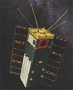
The Hyper-Angular Rainbow Polarimeter (HARP) is a wide field-of-view imaging polarimeter instrument designed for accurate and comprehensive measurements of aerosol and cloud properties from space. The HARP instrument fits in a 1.5U volume, with microelectronics and telemetry optimized for a 3U CubeSat spacecraft. The HARP CubeSat mission is a NASA ESTO InVest project, with joint collaboration between the Earth and Space Institute at UMBC and the Space Dynamics Laboratory (SDL) at Utah State University.
The HARP CubeSat simultaneously samples at 120 unique viewing angles, 4 visible wavelengths, and 3 unique polarization states. Using a combination of polarized information from three co-aligned CCD detectors, the HARP CubeSat produces geolocated, georegistered, gridded, and calibrated Stokes parameters I, Q, and U at narrow spatial resolutions. The polarization separation is done with a modified Phillips prism and wavelength selection via stripe-filter detectors: both advancements in tandem are the key to high polarization accuracy with no moving parts and miniaturization into a CubeSat payload. The HARP CubeSat is scheduled to launch from the orbit of the International Space Station (ISS, 400km) no earlier than November 17th, 2018, for a mission lifetime of one year. The HARP CubeSat science mission will be carried out by the UMBC Department of Physics and the mission operations by SDL.
The HARP CubeSat was replicated into AirHARP, an airborne demonstration of HARP technology, for use on NASA aircraft campaigns. AirHARP participated in the Lake Michigan Ozone Study (LMOS) and the Aerosol Characterization from Polarimeter and LiDAR campaigns in 2017 to demonstrate HARP technology and provide practice datasets for the upcoming HARP CubeSat deployment.
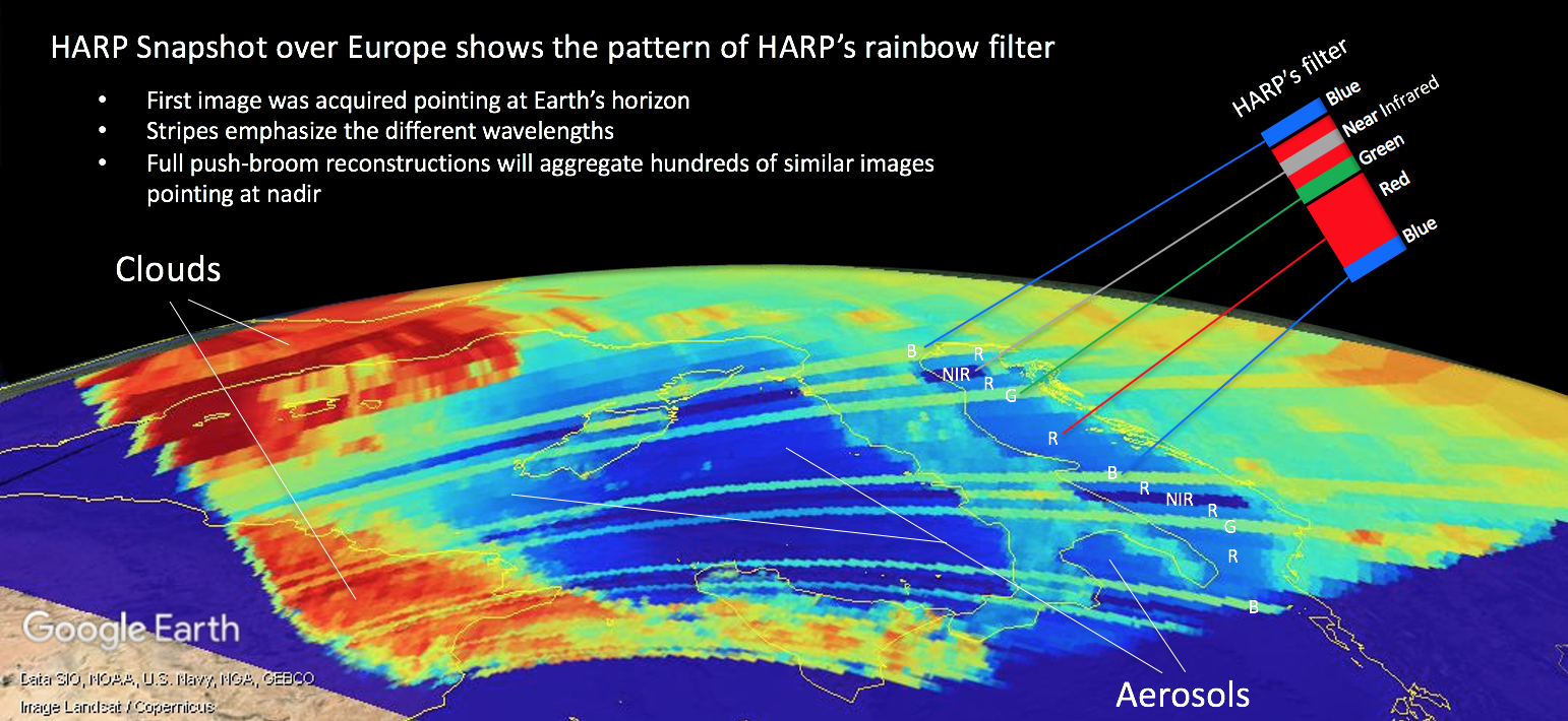
First Light over Europe, 16 April 2020
After several months of commissioning, HARP CubeSat downlinked a first light capture on April 16, 2020. The data was a collection of 10 images from each sensor of the Earth’s limb, facing Europe from the south. The coastlines of Italy, Sardinia, and southeastern Europe are clearly seen in the image below. The regions of high intensity toward western Europe (image left) correspond to clouds. This capture was validated by similar imagery from MODIS Aqua and Terra from the same day. This data capture highlights the sensitivity of the HARP 870nm (near-infrared or NIR) channel to vegetation, too. The 870nm observations over the Italy mainland are very bright compared to the darker ocean surface observed in the same stripe. Note that the neighboring stripe, 670nm (red or R), does not show the same sharp intensity difference between land and ocean. The difference between 670nm and 870nm reflectance of the Earth’s surface is widely used in atmospheric remote sensing to identify chlorophyll-rich areas, both on land (vegetation) and in the water (phytoplankton).
 First Long Data Capture over South America, 05 May 2020
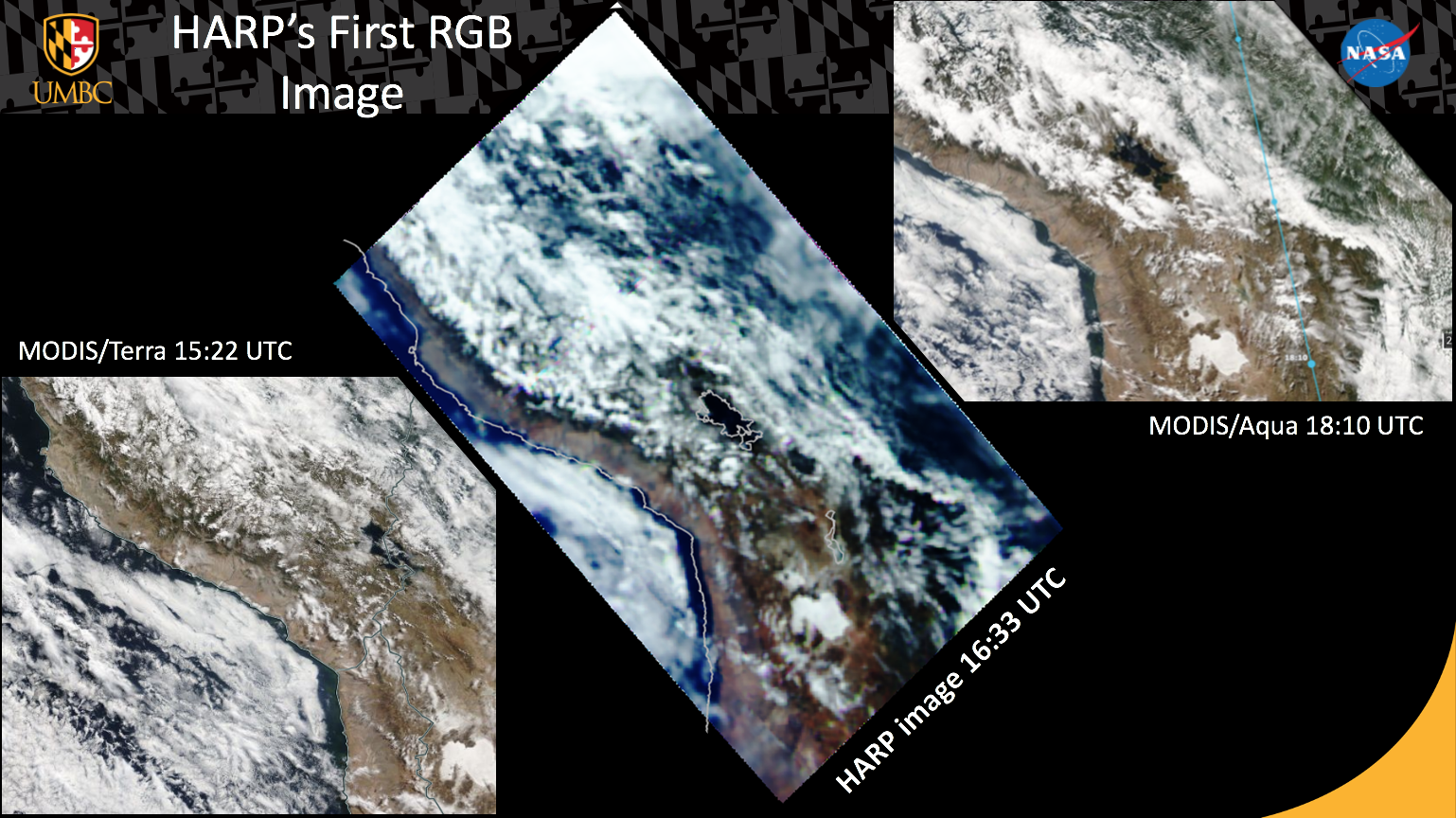
On May 5, 2020, the HARP CubeSat downlinked its first long data capture of 400 images over Lake Titicaca in South America. In post-processing, HARP CubeSat raw images are reconstituted into 120 separate pushbroom scans; each scan represents a single viewing angle from the instrument perspective. Each pushbroom scan (seen below) is projected onto the same surface latitude-longitude grid. By selecting any target pixel in these gridded pushbroom images, we can study how that target scatters light at the four HARP wavelengths and through all 120 distinct viewing angles. This capability is unique to the HARP design and does not exist in any current or prior spaceborne remote sensing instrument.
The image below shows an example of one of the HARP CubeSat pushbrooms over the Lake Titicaca scene. Note the coastal Andes mountains appear to separate the cloud field, the clear sky over the lake, and the Amazon rainforest to the eastern side of the image. Similar images from MODIS Aqua and Terra from the same day confirm the atmospheric and land features seen in the HARP data. This target was chosen specifically because Lake Titicaca is one of the highest natural lakes in the world. It is very useful for clean air vicarious calibration: using the sun’s reflection on the water surface (sunglint) and polarization from atmospheric molecules (Rayleigh scattering), we can track and improve the calibration of HARP CubeSat over the course of the mission.
 The HARP CubeSat science team at UMBC continues to interface with the mission control center at the Space Dynamics Laboratory (SDL) to monitor the health of the instrument, send operational commands, and downlink data to the ground stations. HARP CubeSat data shown here is preliminary and not currently available to the public for science use. Science-quality data from our AirHARP instrument, in the format expected for HARP CubeSat, are publicly available for two different NASA aircraft campaigns on the NASA Langley DAAC server.